Sunday, June 29, 2014

JUNE 29, 1814

200 years ago today in Washington County Indiana Territory, Henry Lukenbill received his deed from the US Government for his title to the northwest quarter of Section 4, T1S, R4E in Blue River Township.  Lukenbill had previously registered his claim to this tract a few years before because it was located on the trace between Beck’s Mill and the Falls of the Ohio.  Lukenbill’s land was well supplied with water as both Dutch Creek and Bear Creek flowed through it near to where each of them emptied into the Mutton Fork of Blue River.  The parcel also was in the tier of oversized quarter sections that were bounded on the north by the base line that ran west from the Initial Point of the Indiana Federal land survey grid established by US deputy surveyor Ebenezer Buckingham, Jr. on September 1, 1805. This meant that this land patent contained about 320 acres in its quarter section instead of the usual 160 acres.  This real estate is located where Dutch Creek Road intersects with Indiana SR 135 in present day Jackson Township.

Henry Lukenbill was another Washington County settler of German descent.  His grandfather is believed to have been of Swiss German Reformed affiliation and to have come to the American Colonies in the 1730s in the wave of immigration from the Palatinate area of present day Germany.  The German spelling of Lukenbill was Lugenbielhl. Henry Lukenbill came to the Indiana Territory from the Abbott’s Creek area of Rowan County, NC as did some of his neighbors on Dutch Creek.  Lukenbill’s land was located west of other neighbors of Teutonic heritage including Henry Wyman, Leonhard Karnes/Carnes, John Bush and George Goss. [See post of May 6, 2014].

David Lukenbill who was a son of Henry Lukenbill had registered for a land patent immediately north of his father in the southwest quarter of Section 33, T1N, R4E.  However, as David was not yet a man of some means as was his father, his claim was assigned to John Shepherd who obtained title in 1819.  This farm along with the neighboring farm of John Strain would later reputedly become the southern junction of the Underground Railroad in Washington County. After the sale of his pending claim, David Lukenbill relocated to the area near Gosport, Indiana at about the time that Ephraim Goss moved there from Washington County. 


Henry Lukenbill was 54 years old at the time he obtained title to his land on the west end of the Dutch Creek community of neighbors of German Calvinist, Pietist and Lutheran origin.  He must have been reasonably prosperous as he paid taxes on 4 horses at 50 cents a head to Harrison County, Indiana in 1812 while his neighbors including Henry Wyman only paid taxes on 1 or 2 horses.  Henry Lukenbill died in 1828 at the age of 65 and his wife Eva died in 1848 at the age of 86.  One of their great grandchildren, Charles F. Lukenbill, owned land on the west edge of Salem and laid out the Lukenbill Subdivision which includes most of the houses on Willow Street in Salem, Indiana today.


Friday, June 27, 2014

JUNE 27, 1814

200 years ago today in Washington County, Indiana Territory, Isaac Newton Blackford who was the County Clerk/Recorder appointed by Governor Thomas Posey in January of 1814 finally had obtained a suitable bound and blank record book in which to transcribe the land transactions occurring with the boundaries of Washington County since its formation out of territory previously located in parts of Clark, Harrison and Knox Counties.  Many documents executed in late 1813 by our forbearers had remained unrecorded because the trip to the court house in Corydon was not convenient to make.  All of the documents executed by the occupants in Washington County in 1814 had remained unrecorded as the newly organized provisional government of Washington County was not yet fully functional.  Isaac Blackford as Recorder had been holding some of these documents for safekeeping until he had a book to record them in.  One of the documents held by Blackford was the original plat for Salem completed by John DePauw on April 4, 1814.

The process of recording a deed in 1814 included the complete transcription of the language of the instrument in a single official public record book.  Blackford could only transcribe two or three documents each day as accuracy of the record was more important than the convenience to the parties to the documented transaction being memorialized.   The first document transcribed for official recording by Mr. Blackford on Monday June 27, 1814 was the plat of Salem prepared by John DePauw as agent for the newly created seat of government for Washington County, Indiana.  The redrawing of the plat of Salem and the transcription of the written description of its assumptions and standards must have taken most of that day.  Isaac Blackford then spent the rest of the work day transcribing the deed in which Benjamin and Catherine Brewer had conveyed their 160 acre land patent in the southwest quarter of Section 17, T2N, R4E to John DePauw on March 18, 1814 for the sum of $1,300.

Isaac Newton Blackford was the subject of a posting in this blog on April  24, 2014.
The reason that it took Blackford over five months to procure an official book to record the land transactions of the residents of Washington County is unknown.   However, as the organization of the collection of tax revenues locally had just been established, it is likely that there were no public funds immediately available to purchase items such as a leather bound record book.  This original record is still on file in the Office of the Recorder of Washington County, Indiana although its leather cover became tattered and thin years ago resulting in its rather plain rebinding.


Thursday, June 26, 2014

 JUNE 26, 1813

201 years ago today in Washington County, Indiana Territory, Zachariah Lindley and Robert Hollowell each received title to land patents that had registered shortly after their emigration to the Indiana Territory from Orange County, North Carolina.  Lindley’s tract was located in the southwest quarter of Section 33, T1N, R2E along the Vincennes Road.  It was the second 160 acre tract that Lindley had purchased from the US Government in this area.  Hollowell’s tract was located in the northwest quarter of Section 3, T1S, R2E.  He received it as assignee of Thomas Hopper who reputed to have been the first squatter in the area that became Washington County, Indiana.  This was the first of eighteen land patents that Robert Hollowell would receive between the years of 1813 through 1838 in Washington, Orange and Lawrence Counties.

In 1809, Zachariah Lindley and Robert Hollowell had preceded a group of Quakers that were led to settlement in the Indiana Territory by Zachariah’s father, Jonathan Lindley, in 1811. During that year, he led a wagon train of emigrants from Orange County, North Carolina to the Lick Creek watershed in the southern part of the Territory of Indiana that was then part of Harrison County.  At the time his son was settling in Indiana two years earlier, Jonathan Lindley made a prospecting trip to Indiana and had purchased a large tract of land where Terre Haute now stands.  The Indian uprising led by Tecumseh and The Prophet in the Wabash region caused the caravan of emigrants to stop in the southern part of the Indiana territory along the Vincennes Road. The trek over the Wilderness Road through the Cumberland Gap and the Kentucky Bluegrass must have been a difficult one for Jonathan Lindley’s wife, Deborah Dicks Lindley, as he died in the Lick Creek settlement on August 10, 1811.  In January of 1814 the Lick Creek neighborhood became part of Madison Township of the newly formed Washington County, Indiana Territory.

Jonathan Lindley was a community leader of great ability and influence.  In North Carolina he was a successful timber and turpentine dealer. He had served 5 terms in the North Carolina House of Commons and had unsuccessfully introduced legislation to limit the importation of slaves in the Tar Heel State.  While in the North Carolina legislature, he refused to vote to ratify the US Constitution until it was amended to include a Bill of Rights.  Upon settlement in Indiana he was a founder of the Lick Creek Friends Meeting in 1813.  This was the second Quaker meeting house in the Indiana Territory and the first in southern Indiana.

His leadership traits were quickly recognized by Territorial Governor Thomas Posey as Lindley was appointed the Presiding Judge of the first circuit court of Washington County in January 1814.  His experience in the North Carolina legislature guided the establishment of civil government in Washington County as the court was the provisional government of Washington County until statehood was achieved in 1816. He was instrumental in getting the territorial legislature to create Orange County, Indiana as of February 1, 1816. When Indiana attained statehood, he was the first representative of Orange County in the General Assembly. As an Indiana legislator, he introduced a bill that provided for a bank at Vincennes. The General Assembly named him to a board that established a State Seminary that later became Indiana University.


Monday, June 23, 2014

JUNE 23, 1810

203 years ago today, David Glass obtained his land patent for the southwest quarter of Section 9, Township 2 North, Range 4 East. On June 23, 1810, Glass was one of the earliest settlers in what was then Washington Township, Harrison County, Indiana Territory to receive a deed from the US Government.  Glass’s immediate neighbors in Section 9 were Moses Hoggatt and William Gordon.  The quarter section assigned by George Brock to Peter Hubbard lay immediately to the west of Glass.  The old trail that ran  from the White River ford to Royse’s Lick cut across the southwest corner of the Glass acreage.  Section 16 lay to the south of Glass and was the school section which was being reserved by the Federal government to provide rental income to support the eventual development of public schools as contemplated by the Northwest Ordinance.  The quarter section tract to the southwest of David Glass had been registered by Jacob Mendenhall and then assigned to Zachariah Nixon on December 10, 1812. 

David Glass had left his pregnant wife, Mehtelina Mary Kime Glass, and one child behind in Guilford, NC while he registered and worked on raising money to perfect his claim in the Indiana Territory.  David Glass was descended from a German family named Gleiss that came to the American colonies in the 1730s.  As his wife was also of Germanic background, Glass did not find himself at ease living around his Quaker neighbors.  Prior to 1814, Glass sold his 160 acres to neighbor Zachariah Nixon after he brought his family to Indiana.  Nixon had to take his deed from Glass to Corydon for recording as the area that was to become Washington County was still part of Harrison County at the time.


David and Mary Glass settled in Washington Township, Clark County, Indiana to the northeast of the Clark Grant where many of his neighbors were of German heritage.  The Glasses raised 8 children in northeastern Clark County and lived there for the rest of their lives.  Mary Glass died in 1862 and David Glass died in 1865 at the age of 83.


Saturday, June 21, 2014

June 22, 1814

200 years ago today, Thomas Posey was the Governor of the Indiana Territory having been appointed by
President James Madison.  He served as the Governor from 1813 until 1816 when Indiana became a state. Following William Henry Harrison’s previous statements as Territorial Governor, Posey advocated the legalization of slavery in Indiana contrary to the provisions of Article 6 of the Northwest Ordinance.  He was vigorously opposed on this position by Territorial Speaker Dennis Pennington of Harrison County and by Congressional Delegate Jonathan Jennings of Clark County. 

Posey had been born in Virginia in 1750 on the plantation adjoining Mt. Vernon which was the home of George Washington.  After distinguished service in the Revolution, Posey received a large land grant for his service.  He selected a tract near Henderson, Kentucky and moved there in 1800.  He became a State Senator and then served as Lieutenant Governor of Kentucky from 1806 to the end of 1808.  He later briefly served as a US Senator from Louisiana after it became a state in 1812.

Posey was considered by the legislature of the Indiana Territory to be inaccessible.  This feeling was exacerbated by Posey’s refusal to live in Corydon which had become the territorial capital in May of 1813.  During his tenure as Governor, he resided in Jeffersonville to be near to his personal physician in Louisville.  A messenger traveled regularly from Corydon to Jeffersonville so that the Governor could communicate with and transmit orders to the territorial government of which Posey was the chief executive.  When Indiana became a state he ran for election as Governor but was defeated by Jonathan Jennings.  Posey was then appointed an Indian Agent for the Illinois Territory and died in Shawneetown, Illinois in 1818.

Throughout the public career of Thomas Posey, he was rumored to be the illegitimate son of George Washington.  Posey simply responded to these rumors by stating that he was born of respectable parentage.  It was an ironic moment when Governor Thomas Posey signed the territorial legislation on December 21, 1813 that created Washington County, Indiana Territory.


Friday, June 20, 2014

JUNE 20, 1814

200 years ago today, John DePauw sold his second set of lots to Joseph Nixon. Nixon bought 2 lots in Salem for the sum of $27.  The lots purchased were 49 and 92.  Lot 49 is located at the southeast corner of North Main and Hackberry Streets.  This is the northwest part of the CVS Pharmacy lot today.   Lot 92 is located at what is today 305 South High Street.  Although, DePauw began selling lots on April 4, 1814, only 2 buyers had paid their purchase amounts in full during the ensuing 77 days.

As Joseph Nixon was the 20 year old son of Zachariah and Martha Toms Nixon, the Nixon family was increasing its stake in the nascent county seat of Washington County, Indiana Territory.  Zachariah and Joseph Nixon now owned 5 lots near to the north line of DePauw’s plat near one of the family’s land patents on the edge on the emerging community of Salem.  The other lot that Joseph Nixon purchased must have been some expression of youthful rebellion as it was at the other end of the plat from his father’s lots and near to the lot that Town Trustee Thomas Beesley had made a down payment on to build his tavern.  The elder Nixon accepted this show of independence as any lot purchased in Salem was likely to make his land on Brock Creek abutting DePauw’s plat on the north more valuable.

Now that Joseph Nixon had some land, his engagement to Ruth Lindley was soon to result in their marriage.  Ruth was the 15 year old daughter of Samuel and Mary Braxton Lindley.  As both families were part of the Quaker settlement in Washington County, the marriage had the blessing of both families.  Between his father’s large land holdings and his future father in law’s successful horse mill operating on the wagon road near Royse’s Lick, Joseph Nixon assumed that his prospects were good on the frontier of the Indiana Territory.

Joseph and Ruth Lindley Nixon began raising a large family quickly as 9 children were born in the next 12 years.  Tragically, Joseph died on May 18, 1828 at the age of 34.  Ruth’s extended family of parents, siblings and inlaws helped her raise the children for the next 5 years.  On January 31, 1833, Ruth married a young widower, Enoch Parr, whose family had come to Indiana from Rowan County NC.   Parr’s first wife, Nancy Carr, died in 1830 with several children surviving her.  They had been part of the Baptist Sharon Church congregation. The blending of Ruth’s 9 children with Enoch’s 6 must not have been a great challenge as they proceed to have another 7 children of their own.
Raising such a large family must have agreed with her as Ruth lived to the age of 90 and died near Harristown, In on June 17, 1889.


Wednesday, June 18, 2014

JUNE 18, 1814

200 years ago this month, Zachariah Lindley may have traveled from his home along the Vincennes Road to visit Beck’s Mill to reminisce with John Beck and Thomas Elliott about their service in the Indiana Militia at the Battle of Tippecanoe in November of 1811.  They had all mustered in the Detachment of Mounted Riflemen of the Indiana Militia on September 12, 1811 that was commanded by Lt. Thomas Berry of Harrison County, Indiana Territory.  Territory Secretary John Gibson who was acting as Governor in the absence of William Henry Harrison had learned of war plans of Tecumseh and his brother, Tenskwatawa (The Prophet) and had called out the Indiana Militia in September.  Hearing of this, Harrison recruited a group of Kentucky volunteers and obtained the services of US Army regulars from the 4th Infantry Regiment and returned to Vincennes to march up the Wabash to Prophetstown.

After a few skirmishes and a logistical delay, Harrison’s command arrived at a location near Prophetstown on November 6, 1811. The Mounted Riflemen were part of the Corydon Yellow Jackets commanded by Captain Spier Spencer of Corydon.  The Yellow Jackets and the Mounted Riflemen were deployed at the south end of Harrison’s forces on a plateau near Prophetstown.  During a predawn surprise attack by Winnebegos who were part of Tecumseh’s coalition, the Harrison County unit took the brunt of the casualties.  Although the ensuing 2 hour battle was considered a victory for the Americans forces because Prophetstown was abandoned the day after battle and then burned down by Harrison’s troops, the losses were heavy.  Out of Harrison’s force of 950, 37 were killed that day; 25 received mortal wounds and died later; and another 126 were wounded in some manner.

Lindley, Beck and Elliott recalled that of the 22 men in the Mounted Riflemen, 4 died in the battle and one died at Vincennes from wounds during the battle of November 7, 1811.  Lieutenant Berry died in the battle.  Frederick Carnes from the Dutch Creek neighborhood was the soldier who died at Vincennes after the battle.  Zachariah Lindley received serious wounds but survived.  Beck, Elliott and Frederick Wyman of the Dutch Creek neighborhood had survived unscathed.

John Beck recalled that Lt. Berry was paid at the rate of $33.33 per month with a daily allowance for his horse of 40 cents per day. Lindley was a Sergeant and was paid $8 per month and a daily allowance for his horse of 40 cents a day.  Beck and Elliott as Privates were paid $6.66 per month and the daily horse allowance of 40 cents per day.  Lindley remarked that he had to encourage Leonard Carnes to open an estate for his son, Frederick, at the Harrison Circuit Court to recover his son’s military pay in the amount of $34.61   Lindley also told his fellow militia men that the widow of Peter Hanks from Harrison County received a pension worth half her deceased husband’s pay for 12 months ($39.96) and a pension for her children of half pay for 26 months. The 3 neighbors then joked about the fact that a Lieutenant was worth more to the Army than his horse but that Sergeants and Privates were not.

John Beck who was a son of George and Elizabeth Claver Beck married Anna Rogers in 1814 and had a family of 10 children.  They eventually moved to Kauffman County Texas where Beck died in 1854.

Zachariah Lindley became a Captain in the Indiana Militia during the War of 1812.  His land patent along the Vincennes Road became part of Orange County, Indiana when that county was created by the legislature of the Indiana Territory on February 1, 1816.  He became the Sheriff of Orange County, Indiana.  His service in the Indiana Militia made him subject to disownment from the Society of Friends.


Thomas Elliott was a native of Rowan County, NC and was a nephew of Elizabeth Claver Beck He was married to Elizabeth Sheets in 1812.  They had 5 children and had moved to Clay County, Illinois by 1820 after Thomas settled the estate of his mother, Susanna Elliott, who died in Washington County, Indiana in 1814.  Her will dated in 1808 was the oldest will on file with Washington Circuit Court. Thomas died in 1842.


Monday, June 16, 2014

JUNE 16, 1814

200 years ago today, Peter Hubbard was celebrating his second anniversary of taking title to his farm located on Brock Creek just northeast of the newly platted town of Salem which was to become the seat of government of Washington County, Indiana Territory.  George Brock had registered the claim for all four quarter sections of Section 8, T2N, R4E and then assigned his claim to the southeast quarter of Section 8 to Peter Hubbard who then received title from the United States on June 16, 1812.

Hubbard was of English extraction having been born in Frederick Co., Maryland in 1754.  His family moved to Pennsylvania and then to Albemarle County, Orange County, and Washington County all in Virginia.  Peter Hubbard and his brother Nicholas followed the Brocks from the panhandle of Virginia to the Indiana Territory in about 1810. Mary Hubbard who was a niece of Peter Hubbard married one of Adam Cauble’s sons, Adam Washington Cauble, and lived to be 100 years of age.

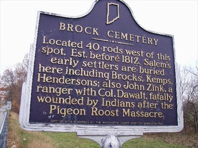
Unfortunately, Peter Hubbard who was a widower when he came to the Indiana Territory did not live long to enjoy the 160 acres he was clearing for a farm as he died in December of 1814.  Hubbard was most likely buried in the Brock Cemetery on a small knoll overlooking Brock Creek immediately west of his land. Peter Hubbard would have been the third burial in this cemetery as a daughter of George Brock, Catherine Brock Neideffer, and a nephew of George Brock, John Zink, were already interred there.  Hubbard’s brother, Nicholas, was appointed to administer his estate.


The farm that George Beck assigned to Peter Hubbard was crossed by the trail that led from the White River ford to Royse’s Lick.  The remnant of this trail is still visible on this land 200 years later.


Sunday, June 15, 2014

JUNE 15, 1814

200 years ago today,  Ursus Americanus [Black Bear] was still living in Washington County, Indiana Territory.  The heavy old growth forest cover of the area with its abundant supply of water and rocky shelter and a small human population provided an ideal habitat for these bears.  The male Black Bear ranged over a territory of approximately 60 square miles while the female ranged over a smaller territory of 15 square miles.  A tributary flowing northeast into the Mutton Fork of Blue River was named Bear Creek by the early settlers of Washington County due to the presence of bears in the area.  Bear meat was a delicacy to the early settlers and bear fat was used for cooking and candles.


Many of the first settlers of the area had encounters with bears that became part of our local lore.  Some of these encounters are set out in the Goodspeed History of 1884 and in the Stevens Centennial History. George Beck and his sons often hunted bear along Blue River near to their mill.   On Christmas Day 1808, they killed one in a cave after waking it from its hibernation.  The cave was probably Charles Cave which is presently owned by the Indiana Department of Natural Resources.  Thomas Hopper who was the first acknowledged settler in the area in 1803 claimed to have killed a female bear and then have taken in her cubs for a brief time.  In 1811, Catherine Karnes found 6 bear cubs about a quarter of a mile from her home near Dutch Creek and took them home.  She raised one of them with her children until the bear was 3 years old.  Jacob Garrett who settled east of Royse’s Lick near the present day boundary between Washington and Franklin Townships, was attacked by a bear without serious injury.  Nathaniel Chambers who was born in Virginia and came to this area from Madison County, Ky settled along Walnut Ridge between the waters of Rush Creek and Buffalo Creek was rescued by his son John from a bear mauling.  Chambers had found the bear in a hollow tree.  His mangled leg caused him to limp for the remainder of his lengthy life as he lived beyond the age of 99.


The last bear in Washington County was killed near Salem in 1825.  The bear was seen in the cemetery that was established in 1824 in the southwestern part of the unplatted land of the acreage purchased by John DePauw from Benjamin and Catherine Brewer in 1814.  The bear was probably attracted to the smell of human remains recently reburied from a previous cemetery located in the southeast part of DePauw’s plat. An impromptu posse of citizens armed themselves and took pursuit.  The bear was fatally shot by Felix D. Badger
who later became the Postmaster at Saltillo.  The bear was brought to Salem on a sled pulled by a team of horses.  It weighed over 400 pounds.  It was skinned, dressed and prepared for a feast attended by about 100 residents of the immediate area.


Bears marked their territory in different ways.  Although the Black Bear was no longer native to this area, Washington County residents would still find bear claw marks etched into beech trees for the remainder of the 19th century.

Charles Major who grew up in Shelby County, Indiana wrote a novel in 1901 about the life of the early settlers of his community that became a Hoosier classic.  The life described in this novel is a good representation of pioneer times in Southern Indiana. If you haven't read "The Bears of Blue River" it might  be time.


Friday, June 13, 2014

JUNE 13,2014

Tonight was the last time that a full moon will occur on Friday 13 until August 13, 2049.  200 years ago, May 13, 1814 was the only Friday the Thirteenth of the year.  The dates of the appearance of a full moon in 1814 were:  January  6;  February  4; March  6; April 4; May  4; June  3;  July   2 ; August 1; August 30; September 29; October 29 ; November 27;  and December  26.

Many of the settlers in Washington County, Indiana Territory used moon signs to guide their planting and their daily activities.  This practice was part of their heritage both from the rural areas of the British Isles and Germany from which they or their ancestors came and from their time in the inland of Pennsylvania, Maryland, Virginia, North Carolina and South Carolina. There was a general belief that the aspects of the moon had an effect on ambient moisture.

Crops and trees that produced above ground fruit and grain were planted during the waxing phase of the moon [between new moon and full moon].  Crops that grew below ground produce were to be planted during the waning phase of the moon [between full moon and new moon]. Harvesting, weeding, tree cutting, and soil preparing were to be done during the waning moon. All gardening was avoided upon the day of the full moon, the days of the quarter moon, and of course, on the new moon.

Other farm and domestic activities were also governed by moon sings.  Rail fences cut during the dry, waning Moon would stay straighter. Wooden shingles and shakes would lie flatter if cut during the dark of the Moon.  The weaning of young livestock wasn’t to begin when the Moon was waning.   The castration  and dehorning of animals was to be performed when the Moon was waning for less bleeding.  The slaughter of livestock was to be done when the Moon was waxing for juicier meat. 


The Old Farmer’s Almanac was a resource often used by pioneers in guiding their conduct according to the phases of the moon.  One can imagine what our Washington County forebearers were doing on particular dates 200 years ago in 1814 by referring to the dates of the full moon listed at the start of this post.


Wednesday, June 11, 2014

JUNE 11, 1814

200 years ago today,  John Garrett and Richardson Hensley were executing their duties as the Co Administrators of the estate of Edmund Hensley who had died a resident of Washington County, Indiana Territory on Wednesday April 13, 1814.  The records of the Washington Circuit Court indicate that Edmund Hensley had served on the first grand jury impaneled in Washington County on April 12, 1814.  Presumably, he died of a heart attack the day after his grand jury duty. He was survived by his wife, Mary Garrett Hensley, and 3 children aged 14 to 1.  Mary Hensley was also pregnant with their 4th child but did not yet know it.  The location of Hensley's burial is not recorded.  He was probably buried on his farm as his Sharon Baptist Church congregation had no church building or lot at the time of his death. His estate was quickly opened by Washington Circuit Court during its inaugural quarterly session in April of 1814. The administrators were the brother in law (Garrett) and the father of the deceased Hensley.  The court also appointed 2 neighbors, Samuel Huston and Jacob Garrett, to act as appraisers of the estate’s property.

Edmund and Mary Garrett Hensley had settled on the western slope of a gentle ridge of high elevation between Spurgeon Hill and Smallwood Knob. Their land was located between 2 tributaries of the Harristown Branch of Royse’s Fork of Blue River about 2 ½ miles east of Royse’s Lick.  They received their title to this 160 acre tract from the Federal Government on April 27, 1813.  Edmund Hensley’s father, Richardson, had registered a claim to land nearby but assigned it to Samuel Herron who took title on December 18, 1813. Part of the Hensley farm was sold during the administration of his estate on November 22, 1817.  John W. Coffey, Alexander Huston and William Herron were appointed commissioners to sign the deed to convey 60 acres to Reese Prichard for $400. 


The Hensleys were both born in Spotsylvania County, Virginia.  They moved to Shelby Co. Kentucky after the Revolutionary War where Edmund married Mary Garrett in 1797.  The Hensley and Garrett families then came to the Indiana Territory about 1811 when Jacob Garrett served in the Indiana Militia. Edmund’s brother Jonathan became the first constable of Washington Township, Washington County, Indiana Territory. Richardson Hensley remained in Washington County for the duration of his life and was buried in the Old Sharon Church cemetery.


The oldest son of Edmund and Mary Hensley, William Richardson Hensley, was married in Bartholomew Co, In. in 1823 and then moved to the  State of Coahualia y Tejas  of Mexico in 1828.  His mother and siblings moved there with him. W. R. Hensley was a surveyor and laid out part of the Stephen Austin colony. He was a close friend of William B. Travis who was the commanding officer at the Alamo.   He became a successful merchant at Port LaVaca, Texas. Mary Garrett Hensley died in Austin, Tx.in 1847.  William Richardson Hensley died in 1849 in a cholera epidemic that would eventually come to Washington County, Indiana in 1851.


Sunday, June 8, 2014

JUNE 8, 1814

200 years ago in Washington County, Indiana Territory, William Lindley, Phillip Stucker and Ephraim Goss were viewing a road “from Salem, to the farm of William Hoggatt from there in a direction toward New Albany passing near Ephraim Goss and then to the County Line”.  William Hoggatt and others had filed a petition with the Washington Circuit Court Judges during their first quarterly session occurring in April 1814 asking that such a public road be established.  Lindley, Stucker and Goss were appointed by the Court to be the viewers to recommend the route of this road.  They were to give consideration to the route that was the most convenient for the public and the least inconvenient for individual landowners along the road

After spending several days on the matter, they determined to recommend that the road run from Salem to the northeast corner of Thomas Hight; then east of William Hoggatt; then to northeast corner of Ephraim Goss and  then generally south along an existing trail that had led to the Buffalo Trace. The ultimate destination of the road, New Albany, was barely a year old but its location below the Falls of the Ohio at the base of the Silver Creek Hills placed it in an advantageous position.

Thomas and Priscilla May Hight were originally from Charlotte County, Virginian where Hight had served in the War of the Revolution.  He had served and the Indiana Militia upon his arrival north of the Ohio and would obtain title to his first Indiana land patent on October 1, 1814 and his second on June 27, 1816.  The Hights later moved to Jackson County and then to Monroe County.  They lived just southeast of  DePauw’s plat of Salem and were pleased that the trail across their partially cleared farm would be maintained at public expense.

Ephraim and Anna Workman Goss came to the Indiana Territory from Rowan County, NC in 1810 and obtained their first land patent on October 3, 1814 in the rolling uplands north of Dutch Creek along the trail that led from the Falls of the Ohio to Royse’s Lick.  Goss was the son of Frederick and Isabella Rickard Goss and grew up in the German Reformed congregation near Lexington NC.  On April 18, 1815. Goss manumitted a slave  named John after a 4 year period of  indenture.   The emancipation papers were drafted by attorney William Hendricks who would later become a US Congressman representing Indiana. Goss moved north in 1818 and took title to land where the 10 O’Clock Treaty Line crossed the West Fork of White River.  In 1829 he gave land that was platted in 1829 as the Town of Gosport which was named after him.  He became a successful processor and shipper of salt and sugar cured pork.  Family legend says that another former slave, Aunt Betsy, continued to live with the Goss family and that she is buried in their family cemetery near Gosport.

Phillip and Mary McCrosky Stucker were married in Franklin County, Kentucky in 1797 and came to the Indiana Territory about 1811 when he served in the Indiana Militia.  The Stuckers eventually were able to purchase their registered land claim from the Federal Government on October 4, 1825.  Their 80 acre farm was located west of Bear Creek just north of the Harrison County Line about a mile west of the road he viewed and helped establish.  The Stuckers live on this farm the rest of their lives and are buried in the Bethlehem Church Cemetery.


This road that Sheriff William Hoggatt and others requested would eventually become Martinsburg Road and Indiana SR 335.   Martinsburg was established along its route in 1818 by Dr. Abner Martin.


Wednesday, June 4, 2014

June 4, 1814

200 years ago today, Jacob Sears had a legal problem with a deed for 4 acres that he bought from Josiah and Sally Wright Johnson on July 31, 1813.  The Johnsons were the first residents of northern Harrison County to sell off a parcel from an original land patent.  They had acquired a quarter section from the Federal Government on August 13, 1812 and a 2d one on August 27, 1812.  Jacob and Mary Huffstutter Sears had registered a claim for the quarter section immediately upstream on Royse’s Fork of Blue River from the Johnsons and obtained their title on August 27, 1813.  The 4 acres purchased from the Johnsons gave the Sears’ more riparian land on the west bank of Blue River which they considered desirable.  As the acerage was on the far north end of the Johnson’s land and remote from their cabin, they were willing to sell to the Sears.

Because the county seat at Corydon was a very difficult trip of considerable distance, the Sears had delayed recording their deed.    Josiah Johnson died in 1813 a few weeks after the deed was signed leaving his wife Sally as a widow with 11 children with all under the age of 15.  After Washington County was created by the legislature of the Indiana Territory and its provisional government organized in January of 1814, the Sears’ now had a convenient location to file their deed for public record.  They were told that the Court Clerk/Recorder Isaac Blackford would not be in a position to accept deeds for recording until July of 1814 as a suitable recording book and filing system was yet to be acquired.  At this time, the Sears’ were also told that although the deed had been witnessed by a neighbor, Noah Fouts, and  relative of Mrs. Johnson, Levi Wright, it had not been witnessed by a Justice of the Peace.  Blackford advised that a new deed could be made by him but as Josiah Johnson was now deceased this was not possible.

The Sears’ also had registered a land claim southeast of Royse’s Lick near to land claim that was registered to  Levi Wright.  Wright  suggested that as his militia service gave him some degree of influence with local officials that a solution to the unattested Johnson deed might be obtained. After some further consultation with Isaac Blackford,  Wright and Fouts were allowed to reattest to their witnessing of the Johnson deed in the presence of the County Recorder.  Disagreement arose as to how Wright and Fouts would formally confirm their witness.  Levi Wright was willing to refer to the deity in his oath but Noah Fouts who was raised as a member of the Church of the Brethren (Dunkard) in the German Pietist tradition would not.   Fouts told Blackford that the taking of oaths was strictly forbidden among the early Brethren because of their understanding of the clear, unambiguous statements of Christ in places such as Matthew 5:34-37. "But I say unto you, Swear not at all; neither by heaven; for it is God's throne: Nor by the earth; for it is his footstool: neither by Jerusalem; for it is the city of the great King. Neither shalt thou swear by thy head, because thou canst not make one hair white or black. But let your communication be, Yea, yea; Nay, nay: for whatsoever is more than these cometh of evil."   Blackford had already encountered this issue with Quaker trasactions as the Society of Friends refused to take oaths also.  Blackford  allowed Fouts to affirm under the penalties of perjury that he had witnessed Johnson’s signature on the deed.  With the method of reattestation determined, the Sears were finally able to deliver their deed for recording on July 10, 1814.
The political savvy of Levi Wright later became apparent as he succeeded his brother, Noah, as Sheriff. Noah Wright was the 2d Sheriff of Washington County having followed William Hoggatt in that office. As a final footnote, this 4 acre tract acquired by the Sears’ from the Johnsons is still described as a separate tax parcel (Tax Parcel Number 88-24-30-000-002.000-021) 200 years later.


Tuesday, June 3, 2014

June 3, 1813

201 years ago today in the northern part of Harrison County, Indiana Territory that later became Washington County, some of the officers of the Indiana Militia made an agreement to merge the companies of Captain Charles Busey, Captain John Royse, Captain Absalom Sergent and Captain Zachariah Lindley into a new batalliion of the 5th Regiment of the Indiana Militia. The officers signing the agreement were:  John Beck, Charles Busey, William Hoggatt, John Royse, James McKinney, Robert Lamb, Jacob Miller, William Cline and Frederick Wyman.  The witness to the agreement was John W. Coffey, Justice of the Peace.

John Beck was of German Lutheran heritage and came to the Indiana Territory from Pennsylvania by way of Rowan County, North Carolina.  He was a son of George Beck and helped him run the mill and clear the 5 land claims he either registered or eventually bought form the Federal Government near Beck's Mill. He relocated to the Republic of Texas in the 1840s.

Charles Busey arrived in the Indiana Territory from North Carolina and bought land from the government near the Wymans, Bushes and Karnes between Dutch Creek and Bear Creek.  He later moved to Rush County, Indiana after it was formed.

William Hoggatt was of Quaker affiliation from North Carolina.  He served in the Territorial Assembly representing Harrison County in 1812.  He became the first Sheriff of Washington County, Indiana Territory when it was formed.  His service in the militia led to his disaffiliation with the Society of Friends. He became involved in land speculation and was part of the company that established Terre Haute, In.

John Royse was a son of Frederick Royse who had operated a trading post and salt works at Royse's Lick in the first years of the 19th century.  He was host to many of the early settlers while they were scouting for land for settlement in what was to become Washington County, Indiana. John Royse was born near Bardstown, Ky in 1780 and died near Fredericksburg, In which his father laid out in 1816.

James McKinney was of Scotch-Irish descent and had registered a claim for land where Livonia is presently located.

Robert Lamb was of Quaker heritage and a son of Simeon Lamb who was a frontier physician at Royse's Lick and one of the first 3 Judges of the Washington Circuit Court in 1814.  Robert Lamb was born in Guilford Co, North Carolina.  Like William Hoggatt, his service in the Militia led to his leaving the Quaker Church.  He moved to Gallatin County, Illinois.

Jacob Miller was probably of  German heritage and worked 4 land claims and took title to 2 of them with the first one being just southeast of Big Spring.

William Cline was of German heritage and a resident of Harrison County.

Frederick Wyman was a son of Henry Wyman who was the son of a Hessian soldier. The Wymans settled along Dutch Creek northwest of what is now Martinsburg. He farmed in Jackson Township, Washington Township, Washington County, Indiana where he died in 1832 survived by his wife Elizabeth Baker Wyman and their 6 children.

John W. Coffey was one of the first justices of the peace in Washington County having settled southeast of Royse's Lick near today's location of Harristown.  He was one of the leaders of the Sharon Baptist Church which was the first congregation functioning in that part of the Indiana Territory which was to become Washington County.


Sunday, June 1, 2014

June 1, 1814

200 years ago today much of Washington County Indiana was covered by a mesic deciduous forest which the first settlers were clearing so as to have land to farm.  Some of this forest had been cleared by the native inhabitants of this land so they could either farm the land or have a clear grazing area around springs and salt licks for easier hunting. When the original land survey was performed by government surveyors around Royse’s Lick in 1806, it was noted that the area was cleared land.  As animals were drawn to the salt lick, native inhabitants would establish settlements in the vicinity so as to enhance their hunting prospects.  Old Ox and his band of Lenni Lenape camped in this area of Washington County at the time of the first settlement of the area by pioneers such as Frederick Royse, Jesse Spurgeon and George Brock.

This forest on the land purchased by John DePauw as the agent for the Washington County seat of government from Benjamin Brewer was described by one of these Federal surveyors as covered with beech, ash and poplar trees with a very thick undergrowth of “spice”.  Witness trees used for marking the section corners and quarter section corners were often dogwood trees.  It was this large mature forest with the thick undergrowth of dogwood and spice that was the major impediment to the sale of the lots that DePauw had platted for purchase and settlement.  On this date 200 years ago, Zachariah Nixon was undoubtedly beginning the process of clearing this thick undergrowth from the lots he had purchased the previous week.

What was this forest understory tree that was called “spice” or “spicewood”?  It was Cercis Canadensis or the Eastern Redbud. In parts of the Appalachian Mountains in Virginia, the Carolinas, Tennessee and Kentucky, green twigs from the redbud tree were used to season wild game such as deer, ground hog and opossum hence the name spicewood.  This designation of the redbud tree as spice by the government surveyors provides a hint as to the origin of a majority of  the original settlers of this part of the Indiana Territory—Virginia and North Carolina by way of Tennessee and Kentucky.

John DePauw was anxious to get the county seat  of Salem established for Washington County, Indiana Territory.  His platted lots went on sale on April 4, 1814  and the first lots didn't sell until May 27, 1814.
During this time the understory of redbud and dogwood under the old growth forest in the Salem plat were in full bloom and color. In 1814, Mr. DePauw may not have been appreciating this natural beauty around him.