Friday, October 31, 2014

OCTOBER 31, 1814

200 years ago in Washington County, Indiana Territory, the settlers of our bicentennial community were often left to their own devices in disposing of the remains of those who died in their family or neighborhood.  Life expectancy at birth in the early 1800s was predicted by the Carlisle Tables to be 38.7 years. With the risks of childbirth, many infants and their mothers were at considerable risk.  The risk of sepsis from poorly treated trauma also contributed to this modest life expectancy.  Finally, the presence of stagnant water in uncleared and undrained river valleys or in crudely impounded streams fostered the spread of water and insect borne diseases that often were fatal.

The burial of a deceased usually had to be conducted within a 24 hour period as there was no available method of preserving a body for a deferred burial.   A person with carpenter skills was summoned to build the crude unlined wooden coffin out of available oak, walnut, poplar, cherry or chestnut boards.  When a person was lingering near death, the coffin was often made while the soon to be departed was still alive.  Upon death, the body was laid on a “cooling” board which may have been an unhinged door or a special board left over from a previous death. Family members would then quickly wash the body and dress it for burial.  In some circumstances a burial shroud was used if clothing was at a premium in the struggling household.  A family member or attending neighbor would then ride from cabin to cabin to inform neighbors and friends of the death. In some neighborhoods all work ceased until the deceased was buried.

As many of the settlers of Washington County were of Pennsylvania, Virginia or North Carolina origin, the Scotch Irish ritual of a death wake was frequently observed the night before the next day’s burial.  This ritual was thought to reawaken the deceased so that they could share in their farewell from our earthly realm. The wake was a social gathering that often provided an amusing diversion from the grief to come including products of the still and fiddle music.  While this neighborhood and family gathering served to comfort the family of the deceased during their time of bereavement, it also served the practical purpose of keeping flies, insects, rats and other vermin away from the body prior to its interment.

The burial itself would have been somewhere on the land of the deceased or his/her family or on unclaimed land nearby.  Few church houses yet existed so there were very few congregational or community grave yards in existence in 1814. Burials of bodies at this time also needed to be close to the home of the deceased’s family so that they could protect the buried remains from scavaging by wolves, bears, wild hogs and grave robbers.  Neighborhood men would dig the grave at the location selected by the family and accept no compensation for their service.  The grave was dug on an east-west orientation so that the decedent faced the rising sun in readiness for "Judgment Day". The funeral service itself would be by the graveside as the decomposition of the body did not allow time for a service at the home or the home where the deceased’s church may have met.  Preachers were often not available on less than a day’s notice to conduct the service so the graveside rite was often conducted by laymen or family.  If the deceased was a member of congregation or an adherent of a particular denomination, the preacher often did a funeral service a few days later.

There are numerous pioneer family graveyards throughout Washington County today.  Some are reasonably well preserved, some may have very weathered or shattered stones,  a few have been relocated to accommodate construction, and some have been obliterated by time, nature or succeeding landowners who had no respect for the graves and gravemarkers of their forebearers.  State law now requires that any know burial on a tract of land be disclosed in a deed when the land is transferred.  The Brock Cemetery north of the Salem Elementary School, the Brewer Blockhouse Cemetery formerly located at the east steps of DePauw Park, and the Philbert Wright Cemetery southeast of Lyndee Lane south of Lake Salinda are three examples of these early cemeteries.

The graves of my ancestors John and Cassandra Crook Collier are examples of the natural destruction of the graves of our early settlers. When John Collier died on September 22, 1831 he was buried on an unoccupied tract of land near his farm on a north facing bluff overlooking the north branch of Lost River.  His wife, Cassandra, died on February 2, 1844 and was buried next to him.  A visit I made to this location several years ago revealed that Lost River had eroded the bluff away many decades ago and had taken the remains of two of my 3rd great grandparents downstream.  This reminded me of the ending of the movie “A River Runs Through It” where the narrator said:
“Eventually, all things merge into one, and a river runs through it. The river was cut by the world's great flood and runs over rocks from the basement of time. On some of the rocks are timeless raindrops. Under the rocks are the words, and some of the words are theirs. I am haunted by waters.”
Norman Maclean, A River Runs Through It and Other Stories


                                            PIONEER WOOD COFFIN

                                                   FUNERAL WAKE

                                       PHILBERT WRIGHT CEMETERY

Thursday, October 30, 2014

OCTOBER 30, 1814

200 years ago today in Washington County, Indiana Territory, the harvest of corn and pumpkins was mostly completed.  The harvest of other crops such as wheat, oats, rye, flax and hay had been completed earlier in the year.  For those families who had completed the purchase of their land claims from the US government and had completed their harvest, the coming winter of 1814 appeared to be manageable. For other families and individuals, the prospects for the winter were not so favorable.  Life on the Indiana frontier of 1814 was still fraught with risk and danger.  Disease, accidents, and childbirth complications left several families without a fully functioning household which was required to survive the rigors of pioneer life.   There were also squatters who had crossed the Ohio River to avoid their creditors who were living in marginal circumstances. Such families and individuals without the support of a larger extended family were facing a bleak winter.  Civil government of the Indiana Territory was organized to provide aid for such persons.

The Northwest Territory had enacted laws as early as 1790 providing for poor relief through public officials designated as overseers of the poor.  These overseers had the duty to investigate the needs of indigent persons and families and to report on their conditions to justices of the peace who could grant aid on a limited basis.
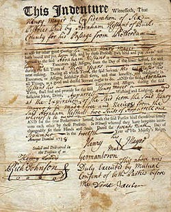
These overseers could arrange contracts for children who were orphans or from indigent families to become indentured apprentices.  Boys were subject to such indentures until they were 21.  The contracts of indenture for girls ended at the age of 18. These overseers could also “farm out” able bodied adults who were unable to support themselves to the lowest bidder.  The landowner paid the overseer for the person’s labor.  The overseer then applied the wages to the needs of the laborer of his family.  Such a contract could extend for a period of up to nine months.

Such a system of poor relief existed in Washington County, Indiana Territory in 1814.  On April 13, 1814, the Washington Circuit Court had appointed two residents of each township to act as Overseers of the Poor.  Some of these appointees were among the most prominent settlers in the county. They were:

Madison Township:                  Owen Lindley and     William Moore
Lost River Town                       James Moorfield and Jesse Roberts
Blue River Town                      Major George Beck and Henry Wyman
Washington Tow                      William Lindley and Zachariah Nixon
Driftwood Town                       Abraham Huff

The provision of poor relief was considered one of the primary functions of local government in the early days of Washington County.  In 1823, poor relief was over 11% of the total county expenditures.  The Stevens Centennial History says that the first pauper was a lady named Elizabeth.  She became a public charge in 1814 and was boarded at the cost of $50 a year until her death in 1833.  When she died her remains received a pauper burial with a shroud at the cost of $1.50, a coffin at the cost of $2 and grave digging and burial at the cost of $2.50.  No monument was included and there was no mention of what the preacher was paid for the funeral service.

This system of public welfare remained in place until 1852 when the Indiana legislature transferred these duties to the office of the township trustee.  To this day, the township trustee has some duty toward providing aid to the poor in the form of rental assistance, utility bills and burial.

  
                                 POOR EMIGRANTS FROM NORTH CAROLINA


                                                       CONTRACT OF INDENTURE


                                      WASHINGTON COUNTY EXPENDITURES 1823

Sunday, October 26, 2014

GENERAL ELECTION 1814

200 years ago in Washington County, Indiana Territory elections were a much simpler civic matter than today.  In fact, the general election of 1814 occurred during the month of August.  Surviving records are rather sketchy as to what offices were determined by this election ordered by the territorial legislature.
The governor was appointed by the President. Some local officials were appointed on a provisional basis by Governor Thomas Posey.  Others were appointed by the three judge panel of the Washington Circuit Court.

There was one territory wide contested race in this election and probably one contest in each district for the Legislative Council.  The freeholders of the Indiana territory voted for the nonvoting delegate that represented the territory in the United States House of Representatives.  Freeholders were considered to be white males over the age of 21 who had paid a poll tax and had lived in the territory for one year.  The votes cast by these freeholders were apparently public as records from Warrick County exist which detail how each person had voted for the congressional delegate.

The candidates for Delegate to Congress in the 1814 election were Jonathan Jennings from Clark County (Charlestown) and Elisha/Elijah Sparks from Dearborn County (Lawrenceburg).  Jennings had served in this capacity since 1809 and was reelected by a wide margin in 1814.  Sparks was a judge in Dearborn County and died soon after the election. Jennings was one of the main opponents to the attempts of William Henry Harrison and Thomas Posey to legalize slavery in the Indiana Territory.  Jennings became the first governor of Indiana when it achieved statehood in 1816.  Jennings County was established in 1817 and was named in his honor. Jennings then served nine terms representing Indiana in the House of Representatives until his death in 1834.

There was one polling location for each township in the 1814 election.  Previously there was only one polling location in each county with vote by voice.  The Washington Circuit Court ordered the following poll locations and election officials:

Township                       Judge                             Place
Madison Twp.                Thomas Fulton              Samuel Chambers residence
Lost River Twp.            Edward Mills                 Jesse Roberts residence
Washington Twp.          Samuel Huston              Salem
Blue River Twp.            John Wright                   Melchoir Fogelmann residence
Driftwood Twp.             Thomas Ewing               Vallonia

The Samuel and Eleanor Lindley Chambers residence was located along the Vincennes Road where they had a store near Half Moon Spring  which is now located in Orange County. The Jesse Roberts residence was located near the north branch of Lost River along the road that led from Beck’s Mill to the Sulphur Spring south of the Cincinnati Road near Orleans. The Melchoir and Elizabeth Meisenheimer Fogelmann residence was located between the Middle Fork of Blue River and Dutch Creek on the road to the Falls of the Ohio that had been rerouted from Royse’s Lick to Salem.  The polling locations in Salem and Vallonia were not noted in the Circuit Court records.


Each election judge maintained the voting ledger and ruled on eligibility.  They then tallied the vote, delivered the ballots and ledger by horseback to Salem and filed them with the Clerk of Court who certified the results and reported the same to the Court.  It is unclear how this was done as the court was not in session until November 1814 and there was no Clerk present in office until September 17, 1814.  The election materials may have been taken directly to the capitol in Corydon given the provisional circumstances of territorial Washington County government. The number of votes cast and the outcome in Washington County is unknown as the present existence of these records is in doubt.  The character and reputation of the election judges appointed by the county Circuit Court was the basis for the integrity of the 1814 election in the Indiana Territory.
                                                  BALLOT BOX

                                   
                                                    PIONEER ELECTION JUDGE


                                                            JONATHAN JENNINGS
                                                 INDIANA TERRITORY DELEGATE
                                                 TO US CONGRESS REELECTED 1814


Friday, October 24, 2014

OCTOBER 25, 1813

201 years ago today in that part of Harrison County, Indiana Territory that would become Washington County, Indiana in January 1814, six families obtained title to their registered land claims from the United States General Land Office.  These family names were Armstrong, Blankenbaker, Gordon, McGrew, McKnight and Wright.

Robert Armstrong received title to the southwest quarter of Section 1, T1S, R3E.  This 160 acres was located north of the Vincennes Road along the Mutton Fork of Blue River.  Today it is found west of Palmyra Road and north of Strickland Road in the eastern part of Posey Township.  Benjamin King had registered the claim to this land earlier and sold his interest to Armstrong who lived in Franklin County, Kentucky at the time.  Armstrong made a second claim to the quarter section to the east and received title to that land on December 26, 1815 thereby owing the entire south half of this section. Robert Armstrong had a wife, Jane, and ten children when he became a landowner in Washington County.  On May 6, 1814 he wrote an elaborate will and took the unusual step of having it filed with the Washington County Recorder while he was still living.  The will reveals that he must have had issues with some of his children as one received one of his farms while another received less than a dollar.  The will also made a specific bequest of his flock of sheep.  The Armstrong Cemetery is on this land today and an Armstrong still owns part of this pioneer homestead.


Lewis Blankenbaker’s deed described his ownership of the northeast quarter of Section 6, T2N, R4E.  This was located immediately northwest of the George Brock settlement along the trail that led from the White River ford to Royse’s Lick. This real estate is located now on the east slope of Highland Creek at the intersection of Spark’s Ferry Road and Water Tower Road. Samuel Blankenbaker who was probably the brother of  Lewis was a neighboring land owner as he had acquired two quarter sections to the south where Kamp Spring was located on Highland Creek.  Lewis and Susannah Utz Blankenbaker were residents of Shelby County, Kentucky and never lived on the Washington County land they had acquired.

Nicholas Blankenbaker who was the father of Lewis and Samuel Blankebaker purchased the southeast quarter of Section 19, T2N, R5E.  This site is located north of State Road 160 about a mile and a half east of the Harristown railroad crossing and includes a reverse drainage tributary of the Middle Fork of Blue River. The Blankenbakers must have been a prosperous Kentucky family as they purchased land in the Indiana Territory for speculation.  Nicholas and Francis Wilhoite Blankenbaker like their son Lewis were residents of Shelby County, Kentucky and never lived in Indiana.  Another son, Solomon Blankenbaker, inherited this farm and it passed on in the family after his death in 1843. Nicholas Blankenbaker was born in Culpepper County Virginia and was a descendant of  Hans Matthias Blankenbaker who came to colonies from Baden-Wurttemburg in Germany.

William Gordon  of  Henry County, Kentucky completed the purchase of his land claim for the northwest quarter of Section 9, T2N, R4E which is located east of Brock Creek on the west side of Jim Day Road. Gordon was born in Bedford County, Pennsylvania and married Angenitie Banta who was born in Lancaster County, Pennsylvania of Dutch descent.  She was the aunt of Jacob Banta who was also an early settler of Washington County. William Gordon operated a still near Brock Creek as did his neighbors George Brock and John Fleenor. [One is tempted to speculate that he made cheap gin.]  William Gordon was one of the victims of the cholera epidemic when he died in July of 1833.

James and Mary Colglazier McGrew moved to the Indiana Territory from Henry County, Kentucky in 1811.  They came from the Drennon’s Creek neighborhood along the Kentucky River downstream from present day Carollton, Kentucky. McGrew first registered a land claim for the northwest quarter of Section 4, T1S, R2E.  This claim was assigned to his father in law, Jacob Colglazier, who received his deed on April 27, 1813. McGrew then claimed and purchased the adjoining southeast quarter of Section 4, T1S, R2E, on October 25, 1813.  This land is located along the Honey Creek sinking creek system where Jacob Doan was one of the other settlers. [See my post of July 34, 2014]  James McGrew was the executor of the estate of his father, Alexander McGrew, and had to make many trips back to Kentucky before its administration was concluded 1824. The McGrews sold their land below the Vincennes Road shortly thereafter and relocated in Clay County, Illinois where he died in 1838 at the age of 55.

William and Nancy Agnes Robertson McKnight were among the many settlers who came from Mercer County, Kentucky by following the route of the Old Trace which passed through the knobs near Pigeon Roost into the Norman Upland. They were among the first to settle in what is now Franklin Township.  Their first land claim was perfected on March 18, 1813 when they obtained title to the northwest quarter of Section 8, T2N, R5E.  They then bought out a claim of Enoch Parr made for the southwest quarter of Section 8, T2N, R5E which was the land they acquired on October 25, 1813.  The McKnight land is located today on the east side of Elliot Road north of the New Philapelphia Road. William McKnight is reputed to have been born in County Down in Ireland in 1765.  He married his wife in Washington County, Pennsylvania.  They lived for a time in Brooks County, Virginia before their settlement in Mercer County, Kentucky.  This sequence of settlement was typical for many of the pioneers of Washington County, Indiana Territory. During the Indian uprising led by Tecumseh and The Prophet, Governor William Henry Harrison ordered in 1811 the construction of neighborhood forts for the protection of the settlers.  One of these forts was built on the McKnight land.  McKnight’s fort was still standing in the early 20th century according to the Stevens Centennial History.  One of William McKnight’s great grandchildren, William McKnight Bloss, became the president of Oregon Agricultural College which is now Oregon State University.

Elijah Wright received his deed on this date for the northwest quarter of Section 6, T1N, R4E.  This land is located on Blue River below the confluence of Royse’s Fork and the Middle Fork of  Blue River near the Cauble Bridge. Elijah Wright was part of a large extended family that came to the Indiana Territory from Rowan and Randolph Counties in North Carolina.  He was the son of William and Elizabeth Morgan Wright who settled on the ridge east of Royse’s Fork and south of Hoggatt Branch.  Four of his uncles also were pioneers in Washington, Harrison and Marion Counties, Indiana.  Elijah Wright served in the Indiana Militia in 1812 and was one of the first Justices of the Peace appointed for Washington County, Indiana.  He married Margaret Holmes Brewer who was the widow of Samuel Brewer after he made his first land claim.  They moved to Driftwood Township, Jackson County, Indiana Indiana where they owned over 400 acres.


The pattern of settlement of these deeds of October 25, 1813 were representative of  where the early residents of our county lived.  Two of these families settled near to the Vincennes Road.  Four of these families settled along parts of the upper Blue River Basin.  

                                   HONEY CREEK SINKING CREEK SYSTEM
                                   JAMES MCGREW


                                        BLOSS HALL @ OREGON STATE UNIVERSITY
                                        NAMED AFTER JAMES MCKNIGHT BLOSS

Thursday, October 16, 2014

OCTOBER 8, 1813

201 years ago today, President James Madison issued 6 deeds through Edward Tiffin as the Commissioner of the General Land Office to settlers of Washington Township of Harrison County, Indiana.  Within 5 months these pioneers became residents of Washington County, Indiana Territory when the new county was created by act of the territorial legislature.  These 6 frontiersmen were: Solomon Bower, Jacob Copple, Elisha Denney, Thomas Evans, Philip Hoggatt and Jacob Motsinger.  Solomon Bower and the Quaker family that bought his 1812 tract are the subjects of this posting.

Solomon Bower and his wife the former Jemima Parr came to the Indiana Territory from Rowan County NC.   The 160 acre tract for which title was granted to them on this date was the southwest quarter of Section 19, T2N, R5E.  This tract was southeast of Spurgeon Hill which was believed to be the highest point in the county.  Bower’s father in law, Arthur Parr, and his brother in law, Enoch Parr, soon purchased land in this neighborhood also. This land is situated today atop the hill east of the Harristown railroad crossing on the north side of State Road 160.  This purchase by the Bowers was the second of five land claims for which they would complete the payment of $2 per acre.  The fifth land purchased by Solomon Bower was for speculation purposes as it was located in Monroe County, Indiana southeast of Louden Ridge.

The first Bower land claim was registered in March of 1811 and deeded on February 15, 1812.  It was located in the northeast quarter of Section 2, T2N, R4E, and was about 3 miles northeast of  Doctor Simeon Lamb’s trading post at Royse’s Lick.  The trail that led from the winter encampment of Old Ox at the salt lick to his summer encampment on the Muscatatuck at the base of the Knobs on the northwest wed of Elk Creek Valley was on the northwest edge of Solomon Bower’s first claim. This first tract must have been substantially improved by Bower as he sold it to Joshua Trueblood on July 21, 1815 for the sum of $1,300.  This must have been the market price for an improved quarter section near to Royse’s Fork of Blue River as this was the same price paid to Benjamin and Catherine Brewer for the quarter section by John DePauw for the land that became the original plat of Salem.  

Joshua and Mary Henley Trueblood were part of the Quaker emigration from Pasquotank and Perquimans Counties in North Carolina to the Indiana Territory.
These two counties were located in the northeast corner of North Carolina and were in the coastal plain between the Albemarle Sound and the Dismal Swamp.
Quaker settlers had the habit of bringing evergreens from North Carolina with them for replanting around their new homes in the developing Northwest Territory.
Joshua Trueblood planted a bald cypress by the house that Solomon Bower had built and planted at least 6 Virginia pines near the barn.  When Joshua Trueblood died in 1853, one of his sons, William Penn Trueblood, acquired this farm.  William Penn Trueblood and his neighbor James Thompson were reputed to be the Quakers most prominently involved in the Underground Railroad.  The Bower farm purchased by the Truebloods sheltered fugitive slaves on their journey to freedom.  The limestone spring house foundation that Solomon Bower built along a tributary of Royse’s Fork of Blue River on this farm is still in place where fugitive slaves would have been refreshed with cool spring water. The cypress tree and 3 of the Virginia pines planted by Joshua Trueblood still stand witness today to this Quaker heritage. 

Solomon and Jemima Parr Bower moved to the farm that they purchased in October, 1813 after the sale of the 1812 purchase.  When Bower’s brother in law, Eli Wright, died in the cholera epidemic of 1833, he became the guardian of his 2 nephews and 1 niece who lived on the lower reach of Royse’s Fork about 3 miles southwest of Salem with their mother, Elizabeth Bower Wright.  As guardian, Bower managed the grist mill that Eli Wright had operated for Johnathon Lyon until he purchased it the year before he died. The foundation stones of the dam for this mill are still visible in the riverbed today. Solomon Bower was my 2d great grand uncle and Eli Wright was my great great grandfather.


                   BALD CYPRESS TREE PLANTED BY JOSHUA TRUEBLOOD IN 1815


               SPRING HOUSE FOUNDATION BUILT BY SOLOMON BOWER
                     ON JOSHUA/WILLIAM PENN TRUEBLOOD FARM

                         DAM FOUNDATION AT ELI WRIGHT GRIST MILL
                         BUILT BY WILLIAM LINDLEY BEFORE 1820


Tuesday, October 14, 2014

OCTOBER 14, 1813

201 years ago in Washington County, Indiana Territory, Robert Bratton received his title to the southeast quarter of Section 11, T2N, R4E.  This tract was adjacent to the tract for which Alexander Little registered his claim.  [See post of April 26, 1814].  This land is found today southwest of the Canton crossroads.

Bratton was born in Augusta County, Virginia in the Shenandoah Valley in 1774.  His grandfather had come to the American colonies from County Donegal in the northwest corner of Ireland. The Brattons crossed the Appalachian divide and were in Kentucky by 1793.  Robert Bratton served as a private in the Kentucky militia where he mustered in at Fort Washington.   Fort Washington was on the Northwest Territory side of the Ohio River and was the main supply point for the protection of Kentucky from attack by Native Americans to the north. Bratton was paid $1 a day for 36 days of service in Captain Ezekiel Hayden’s mounted company. This company was part of the 2d Division of the Kentucky Militia which was commanded by Major General Charles Scott who later became the 4th governor of Kentucky.  Scott County, Indiana is named after him.

By 1801, Bratton was listed as a taxpayer in Franklin County, Kentucky.  He married Nancy McCoskey in 1811.  She was born of a Scottish father and an Irish mother.  They moved to the Indiana Territory in 1813 with a young child and moved onto the land that Bratton purchased on the rolling terrain east of Royse’s Lick 201 years ago today.

The Brattons sold 100 acres of their farm to Jacob and Miriam Bogue Morris on November 19, 1814 for $600.  On the same date they sold the rest of the farm (60) acres to Robert Tilford for $130.  The Brattons then made a 25% down payment on 2 lots in Salem (lots 159 and 160) but then sold their purchase contract to John E. Clark for $8.50 on July 3, 1816.  These lots were located in the very northwest corner of DePauw's original plat on the east bank of Brock Creek.

The Brattons were then drawn to new lands opened up for settlement near Terre Haute, Indiana when they moved to Vigo County in 1816.  He sold one claim in 1823 there and then completed the purchase of 320 acres on January 2, 1828 in the area near Honey Creek which flows west to the Wabash River.  The Brattons had eleven children.  All but one of them moved to the Republic of Texas.

                           AUGUSTA COUNTY, VIRGINIA COUNTRYSIDE


                                              BRIGADIER GENERAL CHARLES SCOTT
                                         FOR WHOM SCOTT COUNTY, IN WAS NAMED


                             GOOGLE EARTH VIEW OF ROBERT BRATTON LAND PATENT

Sunday, October 5, 2014

OCTOBER 3, 1814

200 years ago today in Washington County, Indiana Territory it was becoming apparent that the pace of settlement had picked up once the fear of reprisal and violence inflicted by Native Americans had subsided after the death of Tecumseh at the Battle of Thames near Chatham, Ontario on October 5, 1813.  The defeat of the British and Indian allies at this battle was a crucial victory for the Americans in the War of 1812.  William Henry Harrison who had served as the first territorial governor of Indiana was the commanding officer of the United States forces.  Harrison was aided by Kentucky troops commanded by Isaac Shelby who was the governor of Kentucky at the time.  The death of Tecumseh broke the morale of the various Indian tribes who were attempting to unite into a large confederation to stem the flow of European settlement into the Northwest Territory. The Indiana frontier was safe for settlement from this time on.  Government Land Office records indicate that 63,200 acres were purchased in the Indiana Territory in 1813.  In 1814 823,00 acres were purchased in the Indiana Territory by settlers. The fact that ten different families obtained titles to newly settled land in Washington County on October 3, 1814 is evidence of this developing sense of security.

These new land holders in Washington County were; Robert Catlin; Ephraim Goss; William Hitchcock; James Murphey; John Pettit; Leonard Shoemaker; Edmund Taylor; Caleb Trueblood; Amos Wright and Daniel Zink.

Robert Catlin obtained his land patent to the northwest quarter of Section 12, T1N, R3E, in present day Posey Township.  This tract was north of the Vincennes Road and was located on Blue River upstream from Fredericksburg one bend north of where Licking Creek flows into it.  It is now bounded on the north by Strickland Road and on the east by Palmyra Road.  Catlin was born in Surrey Co NC in 1772.  His first wife died in Kentucky in 1804.  He was then remarried to Mariann Cranch who settled with him and his children along Blue River. Catlin served as an election judge in the 1809 territorial election.  He must have been literate and officious as he was one of the first Justices of the Peace in Washington County.

Ephraim Goss was one of the subjects of my post of June 8, 1814.  He was the son of Frederick Goss and Isabella Rickard/Reichart who lived in Rowan County, NC.  Ephraim married Anna Workman and they came to the Indiana Territory in 1812 with their seven children.  Three more children were born after they settled in Indiana. Three of Ephraim’s siblings David, George and John settled in Indiana also. The land claimed by the Gosses was the northeast quarter of Section 1, T1S, R4E.  The farm was on the road that went from Royse’s Lick to the Falls of the Ohio. It is located today north of Martinsburg between State Highway 339 and Bush Road.  Ephraim and Anna Goss moved north to the west fork of White River in 1821 where he founded the town of Gosport.

William Hitchcock and his wife, Hannah Coffin Hitchcock, came to the Indiana Territory from Guilford County, NC.  They were part of the large contingent of Friends that came to the former Northwest Territory to live away from the slave labor system of North Carolina. The Hitchcocks settled in the northeast quarter of Section 9, T1N, R4E.  This land was located on the middle fork of Blue River immediately south of the quarter section purchased by his father in law, Matthew Coffin in the fall of 1811. Matthew Coffin is the subject of my post of September 14, 1814. Today this property is found on the east side of Blue River Church Road just south of the bridge below the Old Blue River Church.

James Murphey made his home in the northeast quarter of Section 8, T1N, R2E.  This land is today in Orange County, Indiana on the Washington County line.  His first neighbors were William Rigney, George Hinton/Henton, Joseph Wells and Adam Wible. A James Murphey was residing in the Indiana Territory by 1808 while the area was part of Knox County, Indiana.  When he registered his land claim the tract was located within Harrison County.  Within a seven year span he may have lived in four different counties of the growing Indiana Territory although he never moved.

John Pettit and Catherine Covert Pettit received their deed on this date for land located in the northeast quarter of Section 34, T3N, R5E, in the Elk Creek watershed.  This real estate is today located in the Knobs in Gibson Township southwest of Garriott Lake along Old State Road 56.  The Pettits lived in Clark County, Indiana on acreage overlooking the Ohio River near Bethlehem, Indiana. Few pioneers took out land patents in the Knobs themselves as the steep and timbered ridges and hollows were not suitable for crops or grazing.  The Pettits may have been interested solely in the timber resources available although any logs could not be transported to a sawmill until roads were available to serve the area.  Catherine Covert Pettit’s father had come to Clark County, Indiana Territory from New Jersey.  He was a soldier and gunsmith in the Continental Army.  Family tradition says that the Battle of Monmouth was fought near his farm in New Jersey.

Leonard Claiborne Shoemaker/Shewmaker and Eunice Ritchie Shoemaker were born in Virginia in the 1750s.  They were married in Botetourt County, Va. in 1787. They lived for a short time on Duck River in Tennessee and then were in Kentucky where their daughter was married in 1806. They came to Washington County, Indiana Territory in 1814 and immediately paid  the set sum of $320 for the 160 acres of the southeast quarter of Section 12, T4N, R3E.  This land was on the east side of the Driftwood Fork of White River southeast of where Medora is now located.  It became part of Jackson County when it was created by the territorial legislature in January of 1816. The Shoemaker tract is on the border of the consolidated sand dunes which were windblown deposits from the glacial outwash plain of the Illinoian Glacier created about 140,000 years ago.  This is the prime melon growing area today in Jackson County, Indiana.

Edmund H. Taylor bought out two different persons who had registered land claims at the Jeffersonville federal land office.  One claim was purchased by Taylor from Benjamin Shepherd. This claim was for the southeast quarter of Section 11, T1S, R2E.  Shepherd had registered three different land claims in Washington County and sold all of them before paying in full. The other claim was purchased by Taylor from William Welch for the northeast quarter of Section 14, T1S, R2E.  This land lays south of US Highway 150 along State Road 66 southeast of Hardinsburg.  Jacob Doan would have been one of Taylor’s pioneer neighbors.  Taylor’s farm laid along the Sinking Creek system which begins at Cravens Spring northwest of Hardinsburg; goes underground just northeast of the US 150/SR 66 intersection and then emerges at Radcliffe Springs near Blue River.

Caleb Trueblood purchased his land for the US government at the relatively young age of 24.  His chosen tract was the northwest quarter of Section 1, T2N, R4E.  This land is found today south of the intersection of Marrs Road and East Quaker Road along one of the northernmost tributaries of Royse’s Fork of Blue River. Trueblood’s purchase was at the northeast edge of the area of settlement for the Blue River Friends community.  Caleb Trueblood and his brother, William, came to the Indiana Territory from Pasquotank County, NC as did many of his fellow Quakers.  As a young man of prospects with title to 160 acres, Caleb was married to Mary Lindley Pyle in 1816. They raised seven children on their farm until her death in 1845.  Caleb then married Rhoda Coffin Stanley and died in 1857.  One of his descendants was Eugene Trueblood who served many effective terms as Washington County Treasurer and Washington County Assessor.

Amos and Margaret Davis Wright came to the Indiana Territory from Wayne County, Kentucky.  Wright was born in Rowan County, NC and is one of the five sons of Richard Wright, Sr. who settled in the Indiana Territory before Washington County was established.  The tract that Amos Wright received title to on this date was the southwest quarter of Section 4, T1N, R4E.  The land that he received by deed dated October 3, 1814 was the second of four land patents that Wright purchased before 1820. His first tract was where Fort Hill was located and is the subject of my post for May 21, 1814.  The second tract was on the Middle Fork of Blue River northwest of the land claimed by William Hitchcock.  This land today lies west of Blue River Church Road and north of the river.  On this land, Wright built the first church house in Washington County in 1809 as Amos and several of his sons were preachers. The biography of one of his sons, John Wright, says that his father was influenced by Quakers and that his mother was a Dunkard.  This mixture of the inner light and German Pietism led the Wrights to be nondenominational preachers of the Gospel.   His first wife, Elizabeth Lowe, was from a German Dunkard family.  She died in 1805 leaving her husband with eight children surviving.  Amos married Margaret Davis in 1807 and they moved to Indiana soon thereafter.  Six children were born in Washington County, Indiana of this second marriage.  Amos and Margaret are buried in the Old Mill Creek Cemetery near to the church that one of his sons founded.

Daniel Zink received his deed from the Commissioner of the General Land Office on this date as the assignee of Evans Rawley.  Rawley was attracted to the expanding frontier of the former Northwest territory and moved to Jackson County, Vigo County and then to Clay County, Illinois. The land purchased by Zink was the southeast quarter of Section 23, T2N, R3E.  This was a rolling upland on the west bank of Royse’s Fork of Blue River just southwest of the plat of Salem.  It is now located along the east side of Orchard Road and south of the Hanson Quarry.Daniel Zink was born in Frederick County, Virginian of German descent.  His wife, Elizabeth  Shelley, was born in Guilford County, NC.  They began their marriage in Washington County, Virginia which was near Cumberland Gap.  Elizabeth died in 1817 and Daniel moved on to Edgar County, Illinois. Daniel Zink was the brother in law of George Brock.  One of his sons, Peter Zink, lived his entire adult life in Washington County and died at the age of ninety.  Almost all of the Zinks in Washington County today descend from Peter and Sarah Wright Zink.


                                           BATTLE OF THE THAMES IN WAR OF 1812


                                                    GOSPORT, INDIANA FLAG


                                             OLD BLUE RIVER CHURCH CEMETERY


Wednesday, October 1, 2014


OCTOBER 1, 1814

200 years ago today in Washington County, Indiana Territory, four different pioneers were granted land titles by President James Madison acting through the Commissioner of the U. S. General Land Office.  These early settlers of our community were: Abraham Fleenor, Thomas Hight, David W. McKinney and Andrew Pitts.

Abraham and Mary Grace Green Fleenor came to the Indiana Territory from Washington County, Virginia located at the east base of the Cumberland Gap.  They were married there in about 1811 and soon followed the Wilderness Road into the Kentucky Bluegrass where their first child was born.  They then crossed the Ohio River into the uplands and the upper part of the Blue River Basin. They first laid claim to the southeast quarter of Section 32, T3N, R4E, and received that title as of April 27, 1813. This acreage is today located northeast of the right angle turn where Delaney Park Road turns north. Their second land claim was for the southeast quarter of Section 27, T3N, R4E which is the title received by them on October 1, 1814.  This land now is on SR 135 North with the former Quaker Overlook roadside park being in the northwest part of it.  Abraham’s brothers Daniel and John William came to the Indiana Territory at the same time he did.  Daniel Fleenor eventually settled and lived out his life in Rush County, Indiana.  John William Fleenor was among the first to operate a still in Washington County and his domestic life is the subject of my post of July 12, 1814.  Abraham and Mary Grace Fleenor raised eight children and died in 1874 and 1865 respectively and are buried in the Winslow Cemetery.  Peach trees were dedicated at the John Hay Center during Old Settlers’ Days on September 21, 2014 in memory of John and Abraham Fleenor.

Thomas and Priscilla May Hight were mentioned in my post of June 8, 1814.  The land for which they received a deed on October 1, 1814 was the southeast quarter of Section 20, T2N, R4E.  This tract is where Lake Salinda Road angles southeast from SR 135 South.  One of the first roads laid out by the Washington Circuit Court in 1814 that went from Salem toward the Falls of the Ohio was placed along the east line of this land.  The Hights purchased land adjoining to the south in the northeast quarter of Section 29, T2N, R4E, on June 27, 1816.  William and Mary Pitts Lindley, John and Elizabeth Baptiste DePauw, Edward and Martha Raper Cooley, and Andrew and Margaret Braxton Pitts were their immediate neighbors.

David W. and Margaret Wallace McKinney came to the Indiana Territory from Fayette County, Kentucky.  David McKinney was of Scotch-Irish descent and was born in Augusta County, Virginia in the Shenandoah Valley.  After service as an officer in the Revolutionary War when he was wounded in the Battle of Cowpens, he and Margaret were married in Rockbridge County, Virginia in 1785.  In their middle age after all of their eleven children had been born, they followed the Vincennes Road into the Indiana Territory and took out 3 land claims at once on October 1, 1814.  This means that they paid $960 for 480 acres within two or three years which was a considerable sum of money at that time.  Their land purchases were located in the southeast and northeast quarters of Section 7, T2N, R2E and the southeast quarter of Section 17, T2N, R2E.  This land is located today in Orange County, Indiana just west of the confluence of the North and South Branches of Lost River.  These tracts were located near the trace that ran northwest from Beck’s Mill to the Sulphur Spring north of where Orleans is now located.  The road that was established by the Washington Circuit Court in 1814 so that the Lick Creek Friends settlement could have access to Royse’s Lick and the new county seat of Salem passed by this land.  David McKinney died in 1822 and Margaret raised their younger children as a widow.  She died in 1852 at the age of 85.  David and Margaret McKinney are buried in the Trimble Cemetery which near to their pioneer homesteads.


Andrew and Margaret Braxton Pitts were Quakers from the North Carolina Piedmont.  Andrew Pitts was born in Rowan County, NC in 1760.  Margaret Braxton was born in Chatham County, NC in 1768.  They were married in Stokes County, NC where they apparently lived until they came to the Indiana Territory in 1811.  The 160 acres for which they completed their purchase on October 1, 1814 was the northwest quarter of Section 21, T2N, R4E.  This land today is in Salem and includes Reservoir Hill, Etzler Addition and Eastview Terrace Subdivision.  Second of six land claims that Pitts registered between 1811 and 1822.  The first land patent perfected by them was immediately east of the Benjamin Brewer acreage that John DePauw purchased for the original plat of Salem.  That tract had its west boundary on what is today College Avenue. Its north line was an extension of the south line of Salem Avenue and included all of the land occupied by the Fair Grounds and the original part of Smith Cabinet.  The Pitts family sold off the part of this farm located west of Royse’s Fork of Blue River to developers such as Micah Newby and Charles Hay who platted early additions to Salem.  After the death of Andrew Pitts in 1845, his children sold a few small tracts to black families that lived in the “Little Africa” area of Salem until 1864.  Descendants of Andrew and Margaret Braxton Pitts include Pulitzer Prize winning author Booth Tarkington and Arthur Pitts who owned Pitts Package Store on South Main Street.

                                  COWPENS NATIONAL BATTLEFIELD


                                                           BOOTH TARKINGTON
                                            TWO TIME WINNER OF PULITZER PRIZE


                                                        PITTS PACKAGE STORE
                                                     GOOGLE EARTH AERIAL VIEW