On this date Sheriff William
Hoggatt summoned a jury of neighbors to meet him where the Vincennes Road
forded Blue River downstream from where Mill Creek flowed into it. Sheriff Hoggatt was acting under a writ
issued by the Washington Circuit Court. George Beck had appeared before the
Washington Circuit court on in late November 1814 seeking the issuance of a
writ of ad quod damnum so that he determine whether to build a milldam on Blue
River in the southeast quarter of Section 11, T1N, R3E. Beck had obtained title to this land from the
US Government on February 23, 1813. Beck’s
Mill was located in the diagonally adjoining northwest quarter of Section 11,
T1N, R3E. It was at this location in
1808 where George Beck and his sons had dammed the mouth of a cave spring that
had its outflow into Mill Creek. Mill
Creek took its name after Beck’s Mill which was about 2000 feet west of the
site where George Beck was considering building another mill.
“Ad quod damnum” is a Latin
phrase meaning “to what damage”’ It refers to a legal procedure where the sheriff inquires of jurors under oath as to
what damage a grant conferred by government would cause to various people if
the government were to make the grant. It can best be described today as a
private condemnation action. As many watercourses were either on unclaimed
public land or on streams declared to be navigable, the local court was vested
with the authority to control the use of rivers and streams. As the damming of a river would both reduce
the downstream flow and partially flood the river upstream, the value and use
of riparian land by both the US government and landowning neighbors could be
adversely affected. By the assessment of
damages by a jury, the proposing mill operator could determine if he wished to
proceed with the construction of the dam. The downstream owners below
Beck’s proposed milldam were the estate of Susannah Elliot and John
Sheets. The upstream owner with a
potential claim was Jacob Copple.
On the day that John
McPheeters received the verdict on the second slander suit he was litigating,
he hired attorney William Hendricks to obtain a writ of ad quod damnum from the
Washington Circuit Court so that he could construct a milldam on Lost River. Sheriff Hoggatt summoned a jury to assemble
at Lost River on December 3, 1814. The
McPheeters tract was described as the northwest quarter of Section 21, T2N,
R2E. This land today is bounded by Ike
Drew Road on the south; Roger Green Road on the north and the Orange/Washington
County line on the west. Interestingly,
McPheeters was seeking permission to build the milldam before he actually owned
this riparian land along Lost River.
Although he had undoubtedly registered his claim for this tract of land,
McPheeters did not actually make his payment in full until later which resulted
in his deed from the US Government dated April 2, 1818. Upstream occupants with
registered land claims from the McPheeters proposed mill site were George
Arnold and Harvey Finley. The downstream
owner was the trustee of the School Section as Section 16 in each congressional
township was reserved by the Northwest Ordinance to support public
schools. This land was leased by the
agent appointed by the provisional circuit court. David McKinney who had received his land
title on October 1, 1814 was the next downstream owner.
The records of the Washington
Circuit Court do not record what damage assessments these two juries
determined. As there was no operating
watermill in this part of Lost River Township, McPheeters must have thought
that he could get business in this area under settlement that was presently
going to Beck’s Mill on Mill Creek and to Samuel Lindleys Mill near Half Moon
Spring near Lick Creek. There is no record that a milldam was ever built by
John McPheeters or anyone else on Lost River in Washington County, Indiana
Territory.
The reason that George Beck
was interested in building a milldam on Blue River within shouting distance of
his well-known mill is unclear. Maybe
his first mill had so much business that he hoped to draw even more milling
work by having a nearby mill to accommodate the demand for ground grain on the
Washington County frontier. Beck did not
build a mill on his land on Blue River but, a flour mill was built about 1820 near
this location and was operated by Green and then by William Rudder for over 60
years.
The legal procedure used by
George Beck and John McPheeters in the late autumn of 1814 was seldom used by
other settler/entrepreneurs who built dams for the operation of either grist or
saw mills. Mills built by William
Lindley at three locations on Royse’s Fork of Blue River between Brock Creek
and the Middle Fork of Blue River did not use formal legal procedures to have
riparian rights declared. These dams may
have been built before there was a local court conveniently located to deal
with riparian property rights. The
milldam builders may have informally made arrangements with upstream and
downstream owners. These informal
agreements could have been compensated by free or discounted use of grinding or
sawing services at the mill.
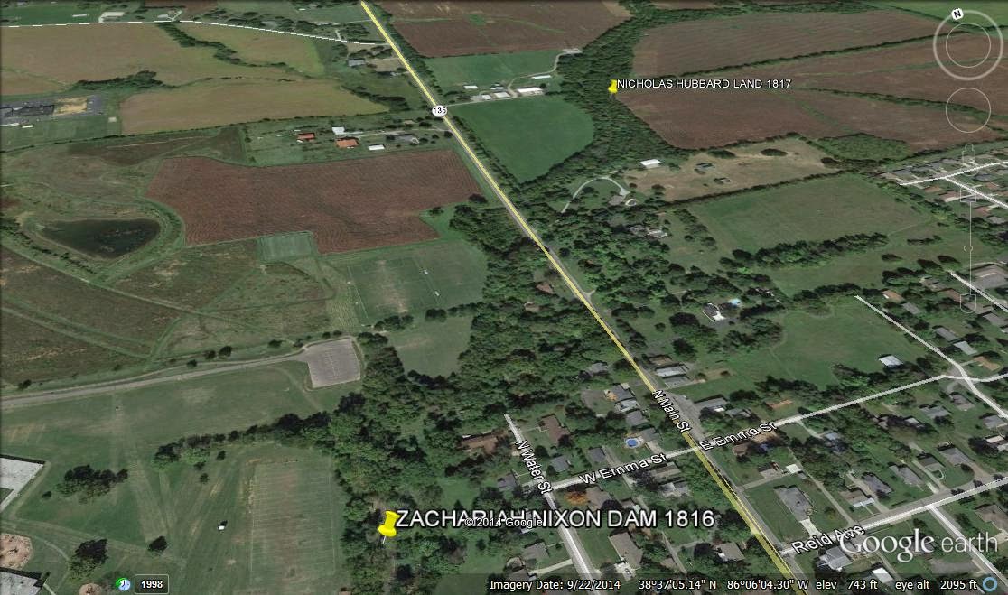
Disputes over the use of
rivers and streams for milldams did arise in the early years of Washington
County, Indiana. In 1816, Zachariah
Nixon built a milldam on Brock Creek downstream from the present day location
of the Salem High School soccer field without using any legal procedure. Nicholas Hubbard who lived upstream from the current
site of the North Main Street Bridge took exception to Nixon’s dam claiming that
his land was damaged by the impounded water.
Hubbard and Nixon entered into a written agreement to choose four
arbitrators to assess any damages that were caused to Hubbard. Nixon also agreed to post a $100 bond to
guarantee payment of any damage award the arbitrators declared. The costs of the proceeding were to be
divided equally. The agreement was witnessed by Justice of the Peace John
McCullough and Jacob Smith on May 23, 1817.
The arbitrators selected were Godlove Kamp, William Lindley, Lewis Crow
and Jeremiah Lamb. These referees viewed the Nixon dam and the Hubbard property
and determined Hubbard’s damages to be $90.
The finding was filed with Justice of the Peace McCullough who then
ordered Nixon to pay the damages every six months in three installments of $30
each.
The result of the
Nixon-Hubbard dispute is somewhat puzzling as George Brock owned land between
the Nixon dam and the Hubbard land.
Looking at Brock Creek today, it is difficult to believe that a dam by
the football practice fields would impound water beyond the bend in Brock Creek
upstream from the SR 135 Bridge. Also the damage award seems rather generous as
George Brock and Nicholas Hubbard only paid $320 for the 160 acres that Hubbard
was protecting from impounded water.
Undoubtedly, early settlers highly valued having access to a free
flowing stream. Perhaps, this is why
John McPheeters who had a successful mill on the Mutton Fork of Blue River never
built a second milldam on Lost River.

GEORGE BECK'S MILL AND MILLDAM ON BLUE RIVER

PROPOSED MILLDAM OF MCPHEETERS ON LOST RIVER

NIXON DAM AND HUBBARD LAND
ON BROCK CREEK
No comments:
Post a Comment